
Hinchinbrook Island: Ancient Aboriginal Country and a Traumatic Colonial History
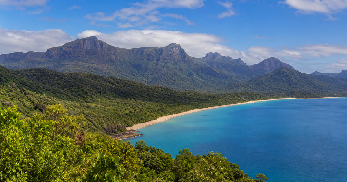
Hinchinbrook Island, known traditionally as Munamudanamy, lies off the North Queensland coast between Lucinda and Cardwell. Separated from the mainland by Hinchinbrook Channel, the island is renowned for its rugged mountains, tropical rainforest, mangroves, beaches and surrounding sea Country.
Today, almost 40,000 hectares are protected within Hinchinbrook Island National Park, which forms part of the Great Barrier Reef World Heritage Area. Yet the island is much more than a spectacular wilderness destination. It is an ancient Aboriginal cultural landscape shaped, known and cared for by Traditional Owners over countless generations.
The Bandjin and Girramay peoples are recognised as Traditional Owners of the island and surrounding region. Historical and linguistic records more specifically associate Hinchinbrook Island and the nearby Lucinda mainland with the Bandjin people, who have also been recorded under names including Biyaygiri and Biyay.

What is the Traditional name for Hinchinbrook Island?
The Traditional name for Hinchinbrook Island is Munamudanamy.
Using this name acknowledges that the island had its own identity, stories and cultural meaning long before it became known to Europeans as Hinchinbrook Island.
For Traditional Owners, Munamudanamy is not simply an isolated island, national park or tourist destination. It forms part of an interconnected cultural landscape encompassing:
- Hinchinbrook Island
- Hinchinbrook Channel
- neighbouring islands
- coastal waters and marine environments
- the adjoining mainland
- ancestral pathways and culturally significant places
The island’s mountains, waterways, plants, animals and sea Country are connected through law, knowledge, story and continuing cultural responsibility.
Why is Hinchinbrook Island culturally significant?
Hinchinbrook Island sustained Aboriginal communities for generations. Its forests, wetlands, rivers, beaches and coastal waters provided fish, shellfish, marine animals, rainforest foods, medicinal plants and materials used for tools, shelter and cultural practices.
Archaeological evidence includes shell middens and stone fish traps. The fish traps demonstrate detailed knowledge of tides, currents and marine behaviour. Fish could be captured and kept alive as tidal waters changed, reflecting sophisticated and sustainable management of sea Country.
Bandjin people were also connected to wider cultural and trading networks. Worked nautilus shells, melo shells and shell necklaces from the Hinchinbrook region were valued and exchanged with neighbouring mainland communities.
Munamudanamy also contains ancestral stories, ceremonial associations, burial places, camps, pathways and named locations. Much of this knowledge remains culturally held and is not publicly documented.
The island’s significance therefore cannot be reduced to individual archaeological sites. The whole cultural landscape is significant, including the relationships connecting people, mountains, waterways, animals, plants and the sea.

Early European contact and colonial expansion
British navigators entered the Hinchinbrook region during the early nineteenth century. Some of the earliest recorded encounters appear to have been peaceful, but relations became increasingly violent as ships, settlers and colonial authorities entered and claimed Aboriginal Country.
The establishment of Cardwell during the 1860s brought sustained colonial intrusion into the region. Aboriginal food sources were disturbed, land was occupied and communities were subjected to growing violence.
Bandjin people resisted the seizure of their Country and attacks upon their communities. However, colonial records often portrayed Aboriginal resistance as criminality or hostility while downplaying or concealing violence committed by settlers and the Native Police.
What happened to the Traditional Owners of Hinchinbrook Island?
The Aboriginal population of Hinchinbrook Island was devastated by:
- frontier violence
- killings and punitive expeditions
- forced dispersal
- introduced diseases
- loss of access to Country
- government control and forced removals
The island did not become largely uninhabited through peaceful migration or natural population decline. Its Aboriginal community experienced catastrophic disruption during the colonial period.
Punitive expeditions and massacres on Hinchinbrook Island
In 1867, Native Police and colonists conducted an extended expedition across Hinchinbrook Island while reportedly searching for information about missing Europeans.
Further violence occurred in 1872 after two European fishermen were killed on nearby Goold Island. Sub-Inspector Robert Arthur Johnstone led Native Police and others through Hinchinbrook Island and neighbouring islands in pursuit of the alleged offenders.
Surviving accounts describe Aboriginal camps being attacked and men, women and children being killed. One later account states that people were cornered on a headland and that those attempting to escape through the water were shot.
Contemporary reports also referred to the destruction of entire camps and to children being captured and taken back to Cardwell.
The precise number of people killed cannot now be established. Native Police operations were frequently poorly documented, deliberately concealed or described through euphemisms such as “dispersal.”
Nevertheless, the historical evidence indicates that Hinchinbrook Island’s Aboriginal community suffered a catastrophic population collapse.

The attempted mission and an almost emptied island
During the 1870s, Reverend Edward Fuller attempted to establish a mission on Hinchinbrook Island.
He reportedly encountered few or no Aboriginal residents during his stay and was informed that violent expeditions had already killed or driven away much of the island’s population.
Survivors appear to have sought refuge with relatives on the mainland or in surrounding coastal districts. Kinship relationships with neighbouring Aboriginal groups would have helped some people survive.
However, displacement separated families from important places and disrupted the transmission of language, ceremony, stories and ecological knowledge.
Government control and forced removals
Aboriginal survivors throughout the wider Cardwell, Tully and Hinchinbrook region were later subjected to Queensland’s restrictive protection system.
Police, protectors and government officials exercised extensive control over Aboriginal people’s lives. Authorities could determine where people lived, where they worked, how they were paid and whether they could travel. Aboriginal people could also be forcibly removed from their Country and sent to government settlements or reserves.
Between 1914 and 1918, 465 Aboriginal people from the Cardwell, Clump Point, Murray River and Tully River districts were forcibly removed to an internment camp at Hull River near present-day Mission Beach.
Many people died there because of disease, inadequate conditions and the effects of a severe cyclone. Survivors were later transferred to other internment camps and institutions.
Not every person removed from these districts was Bandjin, and surviving government records do not always accurately identify an individual’s Country. However, the removal system intensified the displacement already caused by frontier violence and further restricted Traditional Owners’ access to Hinchinbrook Island.
The Traditional Owners were not “wiped out”
Older colonial histories sometimes suggest that the Aboriginal people of Hinchinbrook Island simply disappeared. This description is both inaccurate and harmful.
Although the island’s resident population was almost destroyed and many survivors were scattered, Bandjin and Girramay people survived.
Their descendants continue to identify with, visit and care for Munamudanamy. Girringun Aboriginal Corporation represents Bandjin, Girramay and seven other Traditional Owner groups across the broader region.
Traditional Owners are also involved in caring for and interpreting Hinchinbrook Island National Park.
This continuing connection challenges the colonial idea that Hinchinbrook is an untouched wilderness. The island may appear largely uninhabited today partly because its original population was violently displaced - not because it lacked people, culture or history.

Hinchinbrook Island as a living cultural landscape
Hinchinbrook Island holds two histories that must be understood together.
It is an extraordinary living Aboriginal cultural landscape shaped by ancient ecological knowledge, ancestral law and continuing responsibilities to Country.
It is also a frontier-war landscape where colonial violence nearly destroyed a distinct island community and where that history was later pushed to the margins of public memory.
The growing recognition of the name Munamudanamy, the involvement of Bandjin and Girramay people in caring for the island and the sharing of Traditional Owner history are important steps toward a more truthful understanding of the region.
These actions cannot undo the loss. They can, however, challenge the idea that Hinchinbrook Island’s history began with European exploration or the creation of a national park.
Munamudanamy was - and remains - Bandjin and Girramay Country.